
Bass Fishing - Using Lake Maps To Find Fish
![]()
![]()
![]()
By Rick Seaman and Dan Westfall
Last updated on .
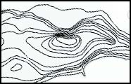
 Fishing maps can help us locate specific areas and general sections of the lake that fit the conditions of the season. Learn to read topographical maps for a better understanding of the lake you plan to fish. Locate river channels, creek channels, flats, road beds, islands, humps and other structural elements that may be keys to finding bass.
3 Most Important Factors About Fishing Maps
- Maps identify the areas most appealing to bass.
- You can find out where the natural river channel runs through a lake.
- You can determine areas with depths ideal for the current season.
Locate potential areas for the current season
 Based on the season you are fishing, you should be able to identify areas of the lake which are most likely to hold bass at this particular time of year. Look for places with appropriate depth that is near deeper water. This is always a good place to start your search.
River channels and adjoining creek channels can be major keys to finding bass. Major coves with creek channels are often more productive than coves simply created by the lay of the land. Drop offs into these channels or other vertical drops near the desired depth can be primary target areas.
Once you determine the depth where bass are currently being caught, look for areas of this depth near structural elements. Mark the map with a highlight marker for easy identification once you are on the water.
Make notes on the map where you catch bass, identified with dates, for future reference. Then you will know areas to start next year during this same season.
Using GPS
A GPS is a great way to mark places you’ve found and caught bass. Every GPS does this differently, so follow instructions that came with your unit. We recommend that you name the location in a way that will help you in future years. Name the location something like Spring09-35ft-ledge. That way you know when to use this spot in the future based on how deep the fish are, as well as what type of structure is holding bass today.
Mapping options are available on most GPS units. If your budget allows, this is a good option for bass anglers as you can follow channels and locate structure right from the GPS unit.

AA Bass Fishing Knowledge Base
- Bass Fishing Overview
- Life Cycle Of Bass
- Seasonal Bass Migration
- Bass Migration - Mid to Late Winter
- Bass Migration - Spring
- Bass Migration - Early Summer
- Bass Migration - Late Summer
- Bass Migration - Fall
- Bass Migration - Early Winter
- Fishing For Bass
- It's Now WHAT You Throw, It's WHERE
- Research The Fishery Before You Go
- Review Contour Maps
- Types Of Cover Used By Bass
- Bass Fishing In Grass Beds
- Bass Fishing In Wood & Timber
- Bass Fishing In Brush & Vegetation
- Establishing Patterns
- Learn To Recognize Bites
- Review Lunar Tables
- Choose The Right Lures
- Find Bass Based On Conditions
- Conditions - Fold Fronts
- Conditions - Wind
- Conditions - Cloudy Days
- Conditions - Fishing In The Rain
- Conditions - Water Clarity
- Conditions - Rising Water
- Conditions - Falling Water
- Conditions - Fishing At Night
- Equipment & Tackle
- Equipment - Fishing Rods
- Equipment - Fishing Reels
- Equipment - Fishing Line
- Equipment - Fishing Lures
- Fishing With Live Bait
- Shallow Water Techniques, 0 -10'
- Shallow Fishing - Spinnerbaits
- Shallow Fishing - Crankbaits
- Shallow Fishing - Top Water
- Shallow Fishing - Pitching & Flipping
- Shallow Fishing - Artificial Worms
- Shallow Fishing - Jigs
- Shallow Fishing - Flukes
- Shallow Fishing - Stick Worms
- Shallow Fishing - Swimbaits
- Fishing Mid Range Depths, 10' - 25'
- Mid Depth - Spinnerbaits
- Mid Depth - Deep Diving Crankbaits
- Mid Depth - Artificial Worms
- Mid Depth - Jigs
- Mid Depth - Swimbaits
- Fishing Deep Water & Structure
- Fishing Deep Water - Jigs
- Fishing Deep Water - Jigging Spoons
- Fishing Deep Water - Artificial Worms
- Planning Your Attack
- Bass Fishing Questions & Answers
- Conservation - Protect The Fishery
Bass information by state
021326
Fishing Information